
The source of the tsunami
The real ocean-floor motion is complicated, and generates waves of many wavelengths. The December 26th tsunami was generated by a sudden large-scale vertical displacement over an earthquake area over a thousand kilometres long in the north-south direction, and a few hundred kilometres wide in the east-west direction. That is easily large enough to generate long waves.
The sea floor moved upwards or downwards so suddenly, in fact, that the ocean above had no time to do anything but follow the vertical motion. The whole ocean was simply lifted up, or fell down, to match the sea-floor motion. That is a very efficient way to generate long waves. The first frame of the movie (approximately 1.4MB, source: PMEL) shows how the ocean surface is lifted up on the west side (orange area), and falls down on the east side (blue area).
The rest of the movie shows the result of running a wave-mathematical computer code that calculates the subsequent long-wave propagation. The computer code, developed at the Pacific Marine Environmental Laboratory, allows for a realistically variable ocean depth D as well as for realistic shoreline shapes. So it simulates many of the refraction and reflection effects, which had different consequences for populations in different regions. For instance, some parts of West Africa were seriously affected, Somalia especially, but not others. Bangladesh got off lightly because of the long north-south dimension of the earthquake area. This meant that the initial pulses of wave energy went mainly eastward and westward.
The diagram above, kindly provided by Professor James Jackson, shows a more detailed view of the vertical displacement profile along the east-west direction. Displacement means, of course, the difference between the sea-floor shapes before and after the earthquake. This is still a simplified view. But it shows the typical jagged profile that results from tectonic plate slippage.
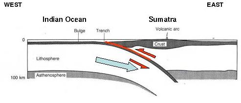
Why does the profile have this jagged shape? It is a characteristic of what earth scientists call a "megathrust earthquake". The reason is that the plate on the left, the Indo-Australian plate, dragged along by the mantle flow beneath it, is thrusting and "subducting" under the plate on the right, the Eurasian plate, as suggested by the blue arrow in the diagram below.
(Image Courtesy Prof. James Jackson)
For centuries the edge of the right-hand plate is inexorably pulled downward, at fingernail-growth speeds, by the left-hand plate thrusting underneath it, until the stress reaches breaking point. The right-hand plate then jerks upward suddenly (red arrows), producing the main upward motion. The sharp corner in the sea-floor displacement picture marks the edge of the right-hand plate. To conserve mass, other parts of the ocean floor have to move downward equally suddenly. The main downward area was to the right, but, luckily for good observers in Sri Lanka, there was some downward motion to the left as well.
The downward motion on the right was part of why Banda Aceh was hit so hard. Not only did the inhabitants have little warning but, to make things worse, Banda Aceh is smack in the middle of the main downward area. A number of centuries from now - no-one can say exactly how many - much the same thing will happen again in much the same place. Professor Kerry Sieh of CalTech and his collaborators have made careful studies of the history of vertical motion in nearby regions, including Simeulue Island off Sumatra, using clever techniques such as the dating of coral reefs.
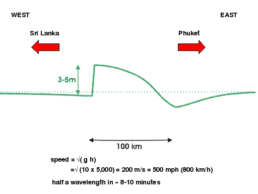
Because of the jagged shape of the vertical displacement profile, waves of many different wavelengths are generated. The shorter waves behave like pond waves, rapidly spreading their energy, and are therefore important only in the near neighbourhood of the earthquake. The long waves, which propagate over trans-oceanic distances with far less energy spreading, have shapes that look like smoothed-out versions of the sea-floor displacement profile. So, for instance the main crest and trough on its way to Sri Lanka had roughly the shape of a long sine wave. (See the section on the speed and power of a long tsunami wave.)
About this article
Michael McIntyre is a Fellow of the Royal Society and a professor of applied mathematics at the Centre for Mathematical Sciences in the University of Cambridge. This Plus article is appearing concurrently with a shorter version commissioned by the Independent Newspaper's new sixth-form careers magazine TheGuide: MATHEMATICS. We are grateful to Professor James Jackson FRS for supplying several of the images and for advice on plate tectonics.
For further information, a reliable source is the website of the Tsunami Research Program of the Pacific Marine Environmental Laboratory in Seattle, Washington, USA.