And now, the weather...

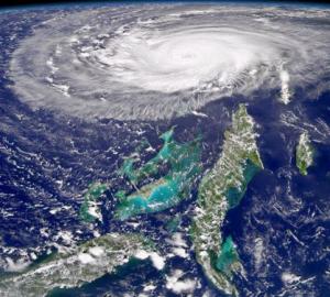
Hurricane Frances looms over Florida and the Bahamas in September (Image from NASA)
Snowstorms strand thousands in South Korea, disastrous summer floods in the UK, the first ever hurricane in the South Atlantic strikes Brazil and two hurricanes on identical paths hit Florida - 2004 has had its fair share of weather surprises, reminding us yet again that accurate forecasts are necessary not only to protect property, but more importantly to save lives.
Currently the Met Office uses a technique called Numerical Weather Prediction (NWP) to forecast the weather for the UK, Europe and the whole globe. Observations of temperature, humidity, wind speed, cloud and precipitation from across the world are updated throughout the day and this information is fed into mathematical models, which predict the weather patterns developing over the next few hours or days. "There has been a steady improvement in the accuracy of the models," said Sean Milton of the Met Office. "On average a three-day forecast today is as accurate as a one-day forecast 20 years ago. However, predicting extreme high impact events can be difficult. The tracks of the large-scale hurricanes which hit Florida were well predicted by our global model but the very localised and small-scale flooding events, such as Boscastle in August, were more problematic even for our finer-scale UK area model."
The Earth's atmosphere is actually a fluid and so its motion is governed by the central equations of fluid dynamics - the Navier Stokes equations. The Met Office's models solve a version of these for fluid dynamical flow on a rotating Earth on a three-dimensional grid, using observations of the current state of the atmosphere as the starting point, and predicting the evolution of the winds, temperature and humidity throughout the atmosphere. (Read more about the Navier Stokes equations in How maths can make you rich and famous from Issue 25 of Plus.)

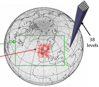
The Navier Stokes equations are solved on a three-dimensional grid over the globe.
The global model (black) has a 60km grid spacing, the European model (green) 20km
and the UK model (red) 12km.
The grid points for the Met Office's global model are currently spaced 60 km apart, those for the European model, 20km apart and those for the UK model, 12 km apart. But many weather phenomena and physical processes, such as radiation, cloud formation and rainfall - and the storms that caused the flooding in Boscastle - occur at a finer scale than this. In the next decade the Met Office hope to improve the resolution of the grids used in their models, and, in particular, to bring down the grid spacing used in the UK model to 4 km in 2005, and to just 1 km by the end of the decade. Preliminary research tests with these 4km and 1km models have had promising results in capturing localised flooding events such as Boscastle.
This is just one of the changes that Met Office scientists hope to implement in the future to improve their forecasting capabilities. Another plan is to use more detailed observation data from satellites to better estimate the current state of the atmosphere, and to improve the way the models describe the physical processes of the weather, such as the daily cycles of cloud formation. And they are also working on a technique called ensemble forecasting, where many forecasts are produced, each from slightly varied initial conditions, to take account of the chaotic nature of the weather and the uncertainties involved in observing the state of the atmosphere.
As the Met Office celebrates 150 years of forecasting, it is looking forward to improving its numerical weather predictions to make even more detailed and accurate forecasts in the future. And although we may never be able to control nature, at least with more accurate forecasts we will be in a better position to prepare for what it throws at us - whatever the weather.